Windhoek - gateway to Namibia's changing landscapes
Most journeys through Namibia begin in Windhoek, the country's capital, where modern city life meets a mix of cultural influences. The city reflects Namibia's Indigenous heritage, its German colonial past, and its more recent journey to independence. Many travellers use Windhoek as a starting point, but it's worth taking the time to get a feel for the city before heading out onto the open roads. Beyond the capital, the scenery changes dramatically from dry central highlands to vast desert plains and rugged Atlantic coastline.
Into the Namib Desert
Stretching along Namibia's Atlantic coastline, the Namib is often described as one of the world's oldest deserts. Its landscape is far more varied than its famous dunes might suggest, with vast gravel plains, rocky outcrops, and dry riverbeds alongside sweeping sand fields. Its coastal setting is unusual: the cold Benguela Current helps create fog that rolls inland, bringing precious moisture to an otherwise arid environment. The Namib Sand Sea, a UNESCO World Heritage Site within Namib-Naukluft National Park, is recognised for its spectacular dunes and remarkable desert ecology.
The proximity to the ocean is one of the things that makes Namibia so distinctive. As Morts explains, "It has such a massive coastal presence which means there are many unique features, as opposed to a landlocked country like Botswana." He also highlights the landscape's "rusty brown, orange, and yellow colours", which stand apart from the greener scenery often associated with an African safari.
How wildlife survives in the Namib
Surviving in the Namib means making the most of very little. Rainfall is scarce, temperatures can swing dramatically, and food is often spread across wide, barren landscapes. Many animals avoid the worst of the heat by sheltering underground or becoming active at night, while some insects collect moisture from coastal fog. Plants have their own strategies, with specialised roots and leaves that help them make the most of limited water. These adaptations remind us that the desert isn't empty or lifeless; it's a finely balanced ecosystem where even small amounts of moisture can make a difference.
Sossusvlei - Namibia's great dune landscape
Sossusvlei is one of Namibia's most recognisable landscapes, known for its towering red dunes, vast salt clay pans, and striking colour contrasts. Located in the Namib-Naukluft National Park, it's undoubtedly a highlight for many visitors. The dunes, which are some of the highest in the world, rise dramatically from the desert floor, forming sweeping ridgelines that stretch towards the horizon. Among the best-known sights is Deadvlei, a white clay pan dotted with the dark, skeletal remains of ancient camel thorn trees, set against the orange dunes and deep blue sky. The trees died centuries ago, and the exceptionally dry conditions have slowed their decay.
Together, the dunes and pans create a landscape that feels almost otherworldly, offering a striking sense of the Namib's scale and geological history. For Morts, seeing the dunes early in the morning is one of Namibia's most memorable experiences. He recalls: "I haven't seen anything like that anywhere on this planet." Their sheer scale and distinctive colour make a lasting impression, as he reflects: "Those are the things that really stick with you."
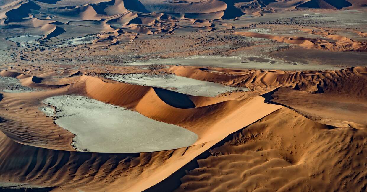
Image credit: Jonathan Hood
Why Sossusvlei looks different throughout the day
The dunes are constantly changing in appearance as the sun moves across the sky. Early in the morning, low-angle sunlight picks out their ridgelines, creating long shadows that emphasise the curves and contours of the sand. As the sun climbs higher, the shadows shorten, and the colours become more intense, shifting between burnt orange, deep red, and golden tones. By midday, the light is harsher, and the desert can feel particularly exposed, while late afternoon brings softer illumination and another opportunity to see the dunes transform.
These constantly changing conditions make Sossusvlei especially appealing to photographers. The contrast between light and shadow creates strong compositions, while the clean lines of the dunes provide striking natural patterns. Even a familiar viewpoint can look completely different a few hours later. Temperatures also vary throughout the day, with cooler conditions around sunrise giving way to intense desert heat later on.
Sesriem Canyon - below the desert surface
Beyond the towering dunes, the Namib has another side at Sesriem Canyon. Carved over millions of years by the Tsauchab River, this narrow gorge cuts through layers of sedimentary rock, reaching depths of around 30 metres in places. Its winding passageways, steep rock walls, and exposed geological layers offer a striking contrast to the open sand seas of nearby Sossusvlei.
The canyon was formed by water rather than wind, with occasional flash floods continuing to shape its course. During wetter periods, pools can collect along the canyon floor, providing a rare source of water in this arid environment. Exploring Sesriem is a reminder that Namibia's desert is far from one-dimensional: its landscapes have been shaped by different forces over vast stretches of time.
Crossing the desert to Namibia's Atlantic coast
The journey from the Namib Desert towards the Atlantic coast reveals another striking side of Namibia's landscape. Travelling west towards Walvis Bay, the road crosses the Kuiseb River area, where rugged canyon scenery and dry riverbeds give way to vast gravel plains and open desert. The Kuiseb River is usually dry, but its underground water supports vegetation that creates a natural boundary between different desert environments. Further west, the landscape seems to run almost seamlessly into the cold South Atlantic, where ocean fog rolls inland across the dunes.
The distances between Namibia's main destinations can be considerable, but Morts believes these journeys are an important part of the experience. As he explains, "Those long drives between the key areas really give you a great amount of time to reflect." Recognising value in the landscapes between the headline stops, he continues: "It's the in between that really adds that intimacy and value."
Walvis Bay - wetlands where desert meets ocean
Where the Namib Desert meets the Atlantic, Walvis Bay offers a surprising change of scenery. Namibia's principal harbour city is best known for its sheltered lagoon, a shallow coastal wetland that provides an important feeding ground for birdlife. The nutrient-rich waters attract large numbers of migratory and resident birds, including flamingos, pelicans, and other waders.
This abundance of life is particularly striking against the desert landscape just beyond the shoreline. The lagoon forms part of the Walvis Bay Ramsar Site, recognised for its international importance as a wetland habitat. It's a striking example of how the coastal environment supports wildlife that you might not expect to find alongside one of the world's driest deserts.
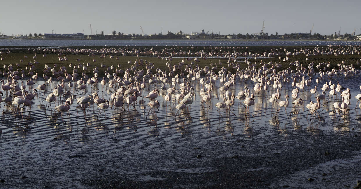
Why are there flamingos in the Namib Desert?
Although the Namib is one of the world's driest deserts, its Atlantic coastline supports surprisingly rich wetland habitats. At Walvis Bay, nutrient-rich waters in the lagoon provide an abundant food source for flamingos, which feed on tiny crustaceans and algae in the shallow water. Both greater flamingos (the larger of the species) and lesser flamingos (which are smaller and generally darker pink) can be spotted here.
Flamingos often gather in large flocks along the shoreline, with their pink plumage creating a striking contrast against the pale salt flats, blue water, and surrounding dunes. The lagoon is also an important stopover for migratory birds travelling along the East Atlantic Flyway, making Walvis Bay a significant destination for birdwatching.
Swakopmund - where the Namib meets the Atlantic
Set between the Namib Desert and the Atlantic Ocean, Swakopmund is one of Namibia's most distinctive coastal towns. Its cooler, often foggy climate offers a welcome contrast to the heat of the desert, while its streets reveal a different side of the country's history. German colonial-era buildings, including the town's lighthouse and historic railway station, give Swakopmund a distinctly European appearance.
Beyond its architecture, the town is a popular base for exploring the surrounding desert and coastline, with opportunities for activities such as sandboarding and scenic excursions into the dunes. It's an unusual meeting point of desert, ocean, and cultural influences, adding yet another dimension to Namibia's varied landscapes.
Cape Cross - one of Namibia's great wildlife spectacles
Namibia's wildlife encounters begin long before you reach Etosha. On the Atlantic coast, Cape Cross is home to one of the world's largest breeding colonies of Cape fur seals, with numbers reaching up to 210,000 during the breeding season in November and December. From the viewing walkway, you can watch thousands crowding the shoreline, swimming in the surf and resting on the rocks, while the air fills with their distinctive calls.
The sheer scale of the colony is difficult to take in. Morts recalls seeing "tens of thousands of seals along this stretch of coastline." It's a very different kind of wildlife experience from the elephants, lions, and other land animals you'll encounter further inland. Morts adds, "It just blows your mind, just the sheer size of it."
Damaraland - Namibia's rocky north-west
In north-western Namibia, Damaraland is known for its rugged mountains, enormous boulders, and open plains, creating one of the country's most distinctive landscapes. The region is also home to desert-adapted elephants, black rhinos, oryx, and springbok, which have evolved to survive in challenging conditions. Its geological highlights include the Petrified Forest, where fossilised tree trunks offer a glimpse into a very different prehistoric landscape. Damaraland also has a rich cultural heritage, with ancient rock engravings at Twyfelfontein among its most significant attractions.
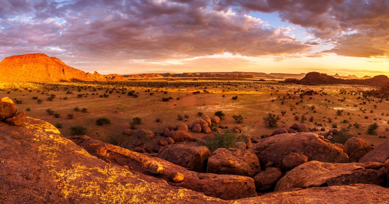
Brandberg - mountains and ancient rock art
Rising above the surrounding plains in north-western Namibia, the Brandberg is the country's highest mountain, reaching 2,573 metres at its summit, Königstein. Its reddish granite slopes conceal thousands of prehistoric rock paintings, including the famous White Lady, found in the Tsisab Gorge. The mountain's striking geology and remarkable collection of ancient artwork make it a significant site for understanding Namibia's archaeological past.
Twyfelfontein - thousands of years of human history in the desert
In the rocky landscape of Damaraland, Twyfelfontein is home to one of Africa's largest concentrations of prehistoric rock engravings. Designated a UNESCO World Heritage Site in 2007, it contains more than 2,000 recorded images, including giraffes, elephants, rhinos, and animal footprints. Created by hunter-gatherer communities over at least 2,000 years, the engravings offer insight into their ritual practices and relationship with the natural world.
From Damaraland to Etosha
Leaving Damaraland behind, the landscape gradually opens out into the flatter plains and savannah of northern Namibia. The rugged mountains and rocky outcrops give way to the grasslands, low shrubs, and stands of mopane woodland, creating a very different setting for wildlife. At the heart of this landscape lies Etosha National Park, dominated by an enormous white salt pan that gives the park its distinctive character. The contrast between Damaraland's rocky terrain and Etosha's open plains is another example of the variety packed into a journey through Namibia.
Etosha National Park
Covering almost 23,000 square kilometres in northern Namibia, Etosha is the country's flagship wildlife destination. Its open grasslands, mopane woodland, and vast salt pan support a remarkable variety of animals. The park is particularly important for black rhino conservation, while its open terrain can make spotting larger animals easier than in more densely vegetated reserves.
What wildlife can you see in Etosha?
Etosha is home to more than 100 mammal species, so there's plenty to look out for on a game drive, including elephants, lions, zebras, springbok, and oryx. You may also see both black and white rhinos, as Morts highlights its "very high population of rhinos". Leopards and cheetahs are also present, although sightings are less predictable.
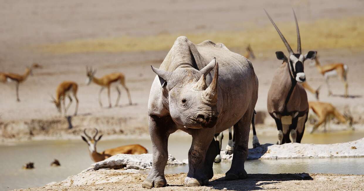
Why Etosha’s waterholes are so important
Waterholes are central to wildlife viewing in Etosha, particularly during the dry season, when natural water sources become scarce. Animals travel considerable distances to drink, creating opportunities to see different species gathering in the same place. Some waterholes are natural springs, while others are supplied by boreholes. Several rest camps also have floodlit waterholes, where visitors may spot nocturnal animals such as black rhinos and lions after dark.
The Etosha Pan
At the heart of the park lies the Etosha Pan, an enormous salt flat covering around 4,730 square kilometres. Its name comes from the Oshindonga word Etotha, meaning "place where no plants grow". For much of the year, the pan is a vast, pale expanse of salt and clay, creating the mirages and shimmering horizons that make this landscape so distinctive. After heavy seasonal rain, part of it can fill with shallow water, attracting flamingos and other waterbirds.
Birdwatching in Etosha
Etosha is also an important destination for birdwatching, with more than 400 recorded species. Its birdlife ranges from large ground-dwelling species such as ostriches and kori bustards to eagles, vultures, and colourful smaller birds. Seasonal rainfall brings another dimension, as temporary pools and flooded areas attract migratory birds, including flamingos and pelicans. The best time for birdwatching is generally during the wetter summer months when the park's changing habitats support greater numbers of waterbirds.
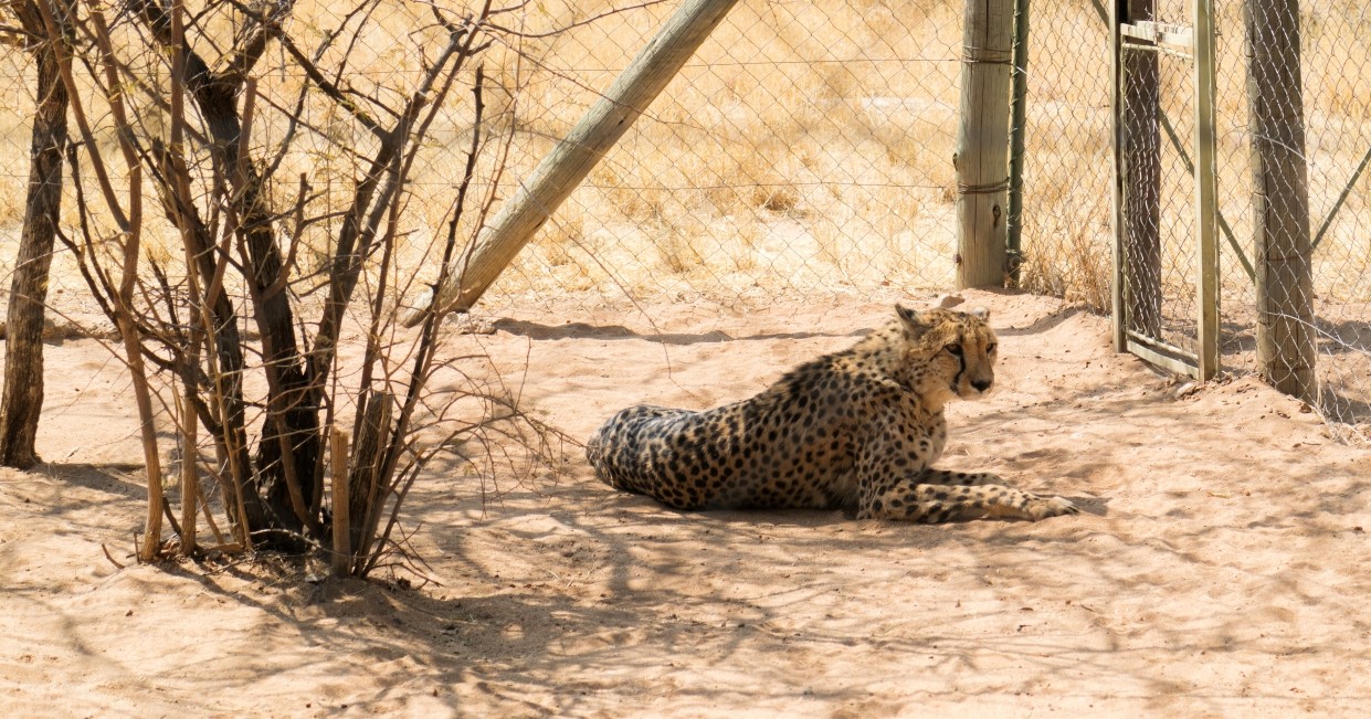
Cheetah conservation near Otjiwarongo
The Cheetah Conservation Fund offers a different perspective on Namibia's wildlife. Rather than simply observing animals in the wild, visitors can learn about the work involved in protecting cheetahs, from research and education to rescuing animals affected by conflict with people. Morts feels the species is often overlooked: "Sometimes the cheetah just flies a bit under the radar."
Morts also highlights the opportunity to learn about different stages of conservation, from anti-poaching work and rehabilitation to the release of animals into the wild. The experience is educational, offering insight into the work involved in protecting a species that can sometimes be overshadowed by Africa's more familiar safari animals.
Otjiwarongo and Otjiwa - a softer wildlife finale
The town of Otjiwarongo provides a final stop in Namibia's wildlife-rich north, with the surrounding countryside offering a quieter contrast to the open plains of Etosha. Nearby, Otjiwa is a privately managed wildlife reserve where guided game drives and rhino tracking offer another chance to encounter some of the country's wildlife. Its conservation work also gives visitors a closer look at the efforts to protect endangered species and manage their habitats.
What should you expect from travelling across Namibia?
Namibia offers a different kind of African adventure. Wildlife encounters are part of the experience, but the country's varied landscapes are just as memorable, from vast desert plains and towering dunes to rugged mountains and the Atlantic coast. As Morts puts it, Namibia is "more than just a safari, yet you still have that sense of adventure when you go there". It's ideal for travellers who enjoy safaris but want to add a different dimension to their trip. Morts also believes it's one of the most beautiful places in the world, with a pristine landscape and a colour palette that's so unique, it's difficult to put into words.